Tennessee Looks Better Every Day
September 26th, 2022New Storm Threatens to Ruin my Fall
Tropical storm preparations continue here at the compound.
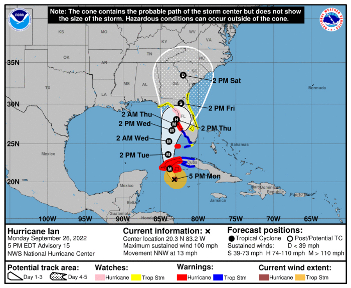
Hurricane Ian’s path has wobbled this way and that over the last couple of days. It was headed for Tampa. Then it was headed for the east side of the panhandle, where there is not much to destroy. Then it turned farther east. Now it’s headed for Tampa again. If it hits Tampa and continues on the present path, the eye will come pretty close to me.
The good thing about this, from my limited perspective, is that the winds that hit here will have to go across a tremendous amount of land first. Land kills storm winds.
Hurricanes circulate counterclockwise, so when one passes near you, you know the directions the wind will take as it goes by. If it passes on the west, as Ian is expected to, the first winds will be from the east, and they will be weakened because they will have to cross Florida twice; first from the Gulf to the east and then from the east to me. After that, there would be southern winds, also weakened, because they will have to come up the middle of the state. Finally, there would be west winds. They would have less resistance, because they would only have to cross from the west coast.
I think the big questions are 1) how wide is the storm, and 2) how strong will it be, generally, when it makes its closest approach to me.
In 2017, Irma spent a lot of time over land before it came near me, but it was very strong when it came ashore, at over 140 mph. It had a hurricane-force wind swath about as wide as Florida until it was about 100 miles south of me, and the tropical-storm-force field was over 5 times the width of the state even after it passed me.
Ian (which Fox is calling a “monster”) looks like it will be much smaller. When Irma was at the stage where Ian is now, it was much, much wider. If Ian stays smaller, the tropical-storm-force band will be narrower and will also have speeds that drop off faster with distance from the eye.
Right now, Tampa’s forecast calls for 80 mph sustained winds, tops, making Ian a Category 1 storm when it hits the coast. That isn’t consistent with other claims I’ve seen. Some news sources say it will be a Category 4. It’s hard to know who is telling the truth because journalists and meteorologists lie about hurricanes so much.
The National Hurricane Center is fairly neutral, so I’m checking their site. They say Ian will DECREASE in intensity after it hits Cuba, so it appears the Cat 4 story is just another media lie. Here’s what they say:
The NHC intensity forecast calls for Ian to become a major hurricane before it reaches western Cuba early Tuesday. It is then forecast to reach its peak intensity over the southeastern Gulf of Mexico in 36 h. After that, southwesterly shear in association with a deep-layer trough over the eastern U.S. is forecast to significantly increase over the hurricane on Wednesday and Thursday, which will likely disrupt the vertical structure and import drier air into its circulation.
They think it will hit land with winds of about 85 mph, and the center of the probability cone is right around Tarpon Springs, about 15 miles north of Tampa.
If this is more or less what happens, things shouldn’t be too bad here. It sounds much better than what the professional liars are saying. I don’t want a Category 4 storm landing 100 miles away.
Anyway, I have propane, a big cooler, water, and as of this afternoon, a generator that sort of works. I should be able to have hot food and refrigeration for two or three days.
I have not finished my tractor fork project. I don’t know if I will get it done by the time the storm comes. I ordered myself a set of clamp-on forks just in case. I need them anyway because they will turn my tractor in to a fairly decent forklift. Brush forks can sometimes be used for forklift duty, but sometimes they won’t fit whatever you’re trying to lift.
Hope I don’t end up bathing in the pool again. Prayers for me and the other people in the cone would be appreciated.